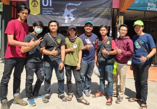
A 7.4 magnitude earthquake and subsequent tsunami struck Palu and Donggala, Central Sulawesi, on September 28, 2018, devastating the city of Palu and its surrounding areas.
To support disaster management, the Geography Department of the Faculty of Mathematics and Natural Sciences, University of Indonesia (UI), sent students from the UI Cares for Palu Action Team to map the areas affected by this devastating disaster.
They were divided into three teams. The first team, consisting of Anggoro Tri Muldiguno, M. Naufal Fahrisa, Ahmad Fakhruddin, and Abdurrahman Aslam, departed for Palu on October 3-10, 2018. The second team, consisting of Muhammad Faris, Dymas Trisna, Faatur Rahman Aditya Pratama, and Tomi Enjeri Siburian, departed on October 10-17, 2018. The third team, consisting of Fuad Ramdhoni, Fernandos, Vita Khairunnisa, and Rijali Isnaini Haripa, departed on October 22-26, 2018.
They made every effort to produce the latest data from recordings of the natural phenomenon in the form of maps.
Taqyuddin, S.Si., M.Hum., a lecturer in the Geography Department of the Faculty of Mathematics and Natural Sciences, University of Indonesia, explained the importance of mapping disaster-affected areas to detect and obtain data on the most severely affected areas and those considered safest.
Furthermore, this mapping can also assist with operational needs in the field, such as the delivery of logistical aid to isolated victims to temporary safe locations (refugees), and the accessibility of officers and volunteers during victim evacuations.
“This way, victim evacuations can be carried out quickly, the number of casualties can be minimized, and logistics can be delivered quickly,” he explained.
Regarding the method, Taqyuddin explained that the geography students conducted direct field surveys using GPS technology to capture spatial data, detecting and documenting the areas they traversed to obtain a picture of the worst-hit areas and those deemed safe. The results can be immediately known because the data is tracked online.tracking secara online.
He believes that the results of this mapping are also crucial in efforts to minimize future damage from recurring disasters.
“Everything will happen again. So, don’t let infrastructure development be wasted,” he concluded.
He further explained that this work will be complete if safe places can be established to sustain the lives of affected communities.
However, he acknowledged that conducting such mapping is not easy. His students face several obstacles during the mapping process, including
the lack of electricity, necessitating spare batteries for equipment; the difficult terrain; and the frequent stench.
“This requires courage, physical and mental strength, and training,” he added.