Author: Taqyuddin, S.Si., M.Hum (Lecturer in Geography, Faculty of Mathematics and Natural Sciences, University of Indonesia)
An earthquake measuring 5-7.4 on the Richter scale, followed by subsequent tremors (less than 5 on the Richter scale), struck the people of Donggala, Palu, and Sigi at the end of September 2018. This was exacerbated by the tsunami and liquefaction, resulting in a high death toll (>1,500), injuries, property damage, and damage to government facilities.
The community was helpless to prevent the disaster. The government and the Indonesian people worked together to alleviate the burden, and international aid arrived for rescue, rehabilitation, and other efforts.
The ongoing learning and adaptation process for dealing with natural disasters cannot be stopped. How can we learn from these events to sustain life in areas affected by the earthquake and tsunami, and to reduce casualties and losses? Disaster management concepts are already abundant, but the concept of finding safe areas seems to have been buried by liquefaction. This is what deserves to be debated in detail, in detail, and systematically. Studying safe areas in detail will include unsafe areas.
Answering this question is not easy, but it is a lesson demanded by the people of Palu, Sigi, and Donggala. While tsunamis can be avoided quickly by staying away from the coast, there are still questions about how this applies to the Donggala region, which has a land distance of no more than 25 km from west to east, similar to the isthmus of Sulawesi.
So, are there safe places to live in this area? The hypotheses could be: 1. Yes 2. No. (an academic assignment for multi- and cross-disciplinary research).
What should be done if “there is a safe place” to live?
What should be done if “there is no safe place” to live?
Discussing the existence and absence of safe places from tsunamis and earthquakes in the Republic of Indonesia (NKRI) requires the hard work of multi- and cross-disciplinary science.
Why do social media and the mass media report on dangerous areas, threats, and disasters? Even down to the details. Are dangerous areas, disasters, and threats a development goal, in such detail? Of course not. But why waste time, money, and energy on activities that aren’t development goals? It’s as if “just find out for yourself if you want to live safely in Indonesia.”
Instead of the founding fathers’ mandate to be humane, just, protected, free, intelligent, orderly and peaceful, prosperous and prosperous, this is the narrative that was chosen and implemented in as much detail as possible as the ideal for the future. (variable continue), mengapa disibukkan dengan yang tidak di narasikan dalam tujuan pembangunan variable-variable discontinue ?
As an analogy, if you want to be smart, go to school. You can determine what is right, good, true, and valuable. Is it true that what we learn in school to be smart is the opposite, for example, don’t associate with corruptors, don’t break the law, don’t insult, don’t…bully, don’t be greedy, or lessons that are prohibited, prohibited this? Narratives of prohibitions, threats, dangers, disasters, and so on can lead to achieving development goals? Why are we invited to be more fluent in understanding dangers and disasters, prohibitions, but do not know which is appropriate, correct, good, and more beneficial and sustainable? This needs to be reflected upon together.
Beyond all that, natural events that teach residents lessons need to be studied and recorded. This is part of a focus on supporting the acquisition of knowledge and understanding of natural phenomena that provide peace, namely finding safe places to live and continue development.
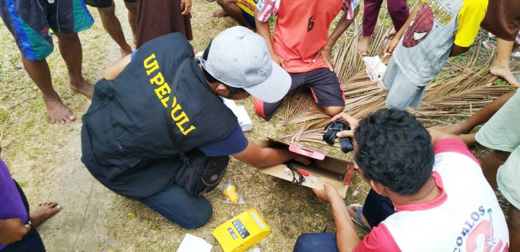
A mapping team of Geography students from the Faculty of Mathematics and Natural Sciences, University of Indonesia (UI), who are members of the UI Cares for Palu Action, immediately headed to the post-earthquake and tsunami location in Palu. They were divided into two teams. The first team departed from October 3-10, 2018, consisting of Anggoro Tri Muldiguno, M. Naufal Fahrisa, Ahmad Fakhruddin, and Abdurrahman Aslam. The second team departed from October 10-17, 2018, consisting of Dymas Trisna, Fatur Rahman Aditya Pratama, Tomi Enjeri Siburian, and Muhammad Faris.
This team is expected to work optimally and produce the latest data from recordings of these natural phenomena in the form of maps. This is a very encouraging first step, producing a map of building and environmental damage and helping determine the correct route to facilitate the delivery of logistics for isolated victims so they can be relocated to temporary safe places (refugees).
This work will be complete if we can delineate safe places for the sustainable livelihoods of affected communities (with little or no disruption to development).