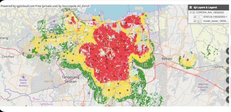
After successfully creating and releasing the Online Map of the Distribution of COVID-19, or SiCovid-19, on March 19, 2020, Ardiansyah, a researcher from the Faculty of Mathematics and Natural Sciences (FMIPA) of the University of Indonesia (UI), and his team, a combination of experts and researchers from the University of Indonesia (UI), under the coordination of the Directorate of Innovation and Science Techno Park, collaborated with the National Disaster Management Agency (BNPB) to develop the InaRISK Portal.
The data and engine developed by UI for the SiCovid-19 portal will be used by the InaRISK Portal to reduce the disaster risk index.
In addition, UI researchers are also currently developing two developments for SiCovid-19. The first is a map of the coverage and average travel time of people to national referral hospitals. This map can show which areas are underserved, as measured by travel time to national referral hospitals.
The second development involves analyzing NO2 concentrations to determine whether physical distancing and working from home are effective in reducing public mobility.
The InaRISK portal (http://inarisk.bnpb.go.id/) is the National Disaster Management Agency (BNPB)’s portal for assessing risks and providing an overview of disaster-threatened areas and affected populations to reduce the disaster risk index.
SiCovid-19 innovator, Ardiansyah, a researcher in the Geography Department of the Faculty of Mathematics and Natural Sciences, University of Indonesia, explained, “The data used by InaRISK is the same as the SiCovid-19 data. We provide a model builder that can be used to generate the model. We provide the engine to BNPB so that BNPB can immediately update data on people who have tested positive for Covid-19, Patients Under Surveillance (PDP), and People Under Monitoring (ODP).”
SiCovid-19 is a webGIS portal created by UI researchers. It has the capability to map the population infected with Covid-19, the distribution of locations of positive Covid-19 patients, and assist the government in mapping areas prone to new infection cases (https://sicovid19-geography-ui.hub.arcgis.com/).
Vice Rector for Research and Innovation, Prof. Dr. rer. nat. Abdul Haris, added, “UI will continue to support the government in dealing with the current global pandemic by deploying a team of experts and researchers to help control the spread of the Covid-19 virus.”